users online
 
Contact me

CHEAP TICKET

I´m normally travel a lot by myself and always I´m trying to find the cheapest ticket to fly, so I´m going to try to help you with your search.

The first thing that you need to know is from where to where do you wand to fly, so I´m going to organice the help by continents.


EUROPE

* The name of the country is just where the company is from, but normaly you can find flys from and for more places.

Ryanair England

Easyjet England

Jet2 England

Flybe England

Airberlin Germany

Germanwings Germany

Aerlingus Ireland

Skyeurope East Europe

Meridiana Italy

Volareweb Italy

Spanair Spain

Iberia Spain

Clickair Spain

Vueling Spain

Condor

Sterling Denmark

Brusselsairlines Belgium

Thomascookairlines Belgium

Norwegian Norway

Air Bulgary

Smartwings

Click4sky Czech Republic

Airbaltic Baltic Republics

Finnair Finland

Finncomm Finland

Blue1 North Europe

Flysas Scandinavia

Arkefly Netherlands

Martinair Netherlands

Transavia Netherlands

videos video photo photos pictures fotos United States Estados Unidos US USA travel trip holiday vacation vacaciones gratis free http://goplanettravel.blogspot.com goplanettravel gotravelphoto

ARIZONA, UNITED STATES


Places that I visited:

Antelope Canyon

Cameron

Grand Canyon

Hoodoos

Horseshoe Bend

Lake Powell

Marble Canyon

Montezume Castle National Monument

Native Americans

Navajo Bridge

Navajo National Monument

Paria Canyon

Rock Houses

Saguaro National Park

The Wave

Walnut Canyon National Monument

Willians, Historic Route 66


Arizona is one of the most beautiful State in United States, you can find a big range of landscapes, as the Grand Canyon, Saguaro National Park, …

The State of Arizona is a state located in the southwestern region of the United States. The capital and largest city is Phoenix. The second largest city is Tucson, followed by the four Phoenix-area conurbation cities of Mesa, Chandler, Glendale, and Scottsdale.

Arizona was the 48th and last of the contiguous states admitted to the Union on February 14, 1912. Arizona is noted for its desert climate, exceptionally hot summers, and mild winters, but the high country in the north features pine forests and mountain ranges with cooler weather than the lower deserts. New population figures for the year ending July 1, 2006 indicate that Arizona was at that time the fastest growing state in the United States, exceeding the growth of the previous leader, Nevada.

Arizona is one of the Four Corners states. It borders New Mexico, Utah, Nevada, California, touches Colorado, and has a international border with the states of Sonora and Baja California in Mexico.

Marcos de Niza, a Spanish Franciscan, explored parts of the area in 1539 and met some of its original native inhabitants, probably the Sobaipuri. The expedition of Spanish explorer Coronado entered the area in 1540–1542 during its search for CĆ­bola. Father Kino was the next European in the region. A member of the Society of Jesus, he led the development of a chain of missions and converted many of the Indians to Christianity in the PimerĆ­a Alta (now southern Arizona and northern Sonora) in the 1690s and early 18th century. Spain founded presidios (“fortified towns”) at Tubac in 1752 and Tucson in 1775. When Mexico achieved its independence from Spain in 1821, what is now Arizona became part of the Territory of Nueva California, also known as Alta California. In the Mexican–American War (1847), the U.S. occupied Mexico City and pursued its claim to much of northern Mexico, including what later became Arizona. The Treaty of Guadalupe Hidalgo (1848) specified that the sum of US$15 million in compensation (equivalent to about $380 million in 2012) be paid to the Republic of Mexico. In 1853, the land below the Gila River was acquired from Mexico in the Gadsden Purchase. Arizona was administered as part of the Territory of New Mexico until southern New Mexico seceded from the Union as the Confederate Territory of Arizona on March 16, 1861. Arizona was recognized as a Confederate Territory by presidential proclamation of Jefferson Davis on February 14, 1862. This is the first official use of the name. A new Arizona Territory, consisting of the western half of New Mexico Territory was declared in Washington, D.C., on February 24, 1863. The new boundaries would later form the basis of the state.

Although names, including “Gadsonia”, “Pimeria”, “Montezuma” and “Arizuma” had been considered for the territory, when President Lincoln signed the final bill, it read “Arizona”, and the name became permanent. (Montezuma was not the Aztec Emperor, but the sacred name of a divine hero to the Pima people of the Gila River Valley, and was probably considered—and rejected—for its sentimental value before the name “Arizona” was settled upon.)

Brigham Young sent Mormons to Arizona in the mid-to-late 19th century. They founded Mesa, Snowflake, Heber, Safford and other towns. They also settled in the Phoenix Valley (or “Valley of the Sun”), Tempe, Prescott, and other areas. The Mormons settled what became northern Arizona and northern New Mexico, but these areas were located in a part of the former New Mexico Territory.
During the Mexican Revolution from 1910 to 1920, a few battles were fought in the Mexican towns just across the border from Arizonan border settlements. Throughout the revolution, Arizonans were enlisting in one of the several armies fighting in Mexico. The Battle of Ambos Nogales in 1918, other than Pancho Villa’s 1916 Columbus Raid in New Mexico, was the only significant engagement on U.S. soil between American and Mexican forces. The battle resulted in an American victory. After U.S. soldiers were fired on by Mexican federal troops, the American garrison then launched an assault into Nogales, Mexico. The Mexicans eventually surrendered after both sides sustained heavy casualties. A few months earlier, just west of Nogales, an Indian War battle occurred, thus being the last engagement in the American Indian Wars which lasted from 1775 to 1918. The participants in the fight were U.S. soldiers stationed on the border and Yaqui Indians who were using Arizona as a base to raid the nearby Mexican settlements, as part of their wars against Mexico.

Arizona became a U.S. state on February 14, 1912. This resulted in the end to the territorial colonization of Continental North America. Arizona was the 48th state admitted to the U.S. and the last of the contiguous states to be admitted.
Cotton farming and copper mining, two of Arizona’s most important statewide industries, suffered heavily during the Great Depression, but it was during the 1920s and 1930s that tourism began to be the important Arizonan industry it is today. Dude ranches, such as the K L Bar and Remuda in Wickenburg, along with the Flying V and Tanque Verde in Tucson, gave tourists the chance to experience the flavor and life of the “old West”. Several upscale hotels and resorts opened during this period, some of which are still top tourist draws to this day; they include the Arizona Biltmore Hotel in central Phoenix (opened 1929) and the Wigwam Resort on the west side of the Phoenix area (opened 1936).

Arizona was the site of German and Italian POW camps during World War II and Japanese-American internment camps. The camps were abolished after World War II. The Phoenix area site was purchased after the war by the Maytag family (of major home appliance fame), and is currently the site of the Phoenix Zoo. A Japanese-American internment camp was located on Mount Lemmon, just outside of the state’s southeastern city of Tucson. Another POW camp was located near the Gila River in eastern Yuma County. Because of wartime fears of Japanese invasion of the west coast, all Japanese-American residents in western Arizona were required to reside in the war camps.

Arizona was also home to the Phoenix Indian School, one of several federal institutions designed to forcibly assimilate Native American children into Anglo-American culture. Children were often enrolled into these schools against the wishes of their parents and families. Attempts to suppress native identities included forcing the children to cut their hair and take on English names.

Arizona’s population grew tremendously after World War II, in part because of the development of air conditioning, which made the intense summers more comfortable. According to the Arizona Blue Book (published by the Arizona Secretary of State’s office each year), the state population in 1910 was 294,353. By 1970, it was 1,752,122. The percentage growth each decade averaged about 20% in the earlier decades and about 60% each decade thereafter.

The 1960s saw the establishment of retirement communities, special age-restricted subdivisions catering exclusively to the needs of senior citizens who wanted to escape the harsh winters of the Midwest and the Northeast. Sun City, established by developer Del Webb and opened in 1960, was one of the first such communities. Green Valley, south of Tucson, was another such community and was designed to be a retirement subdivision for Arizona’s teachers. Many senior citizens arrive in Arizona each winter and stay only during the winter months; they are referred to as snowbirds.

In March 2000, Arizona was the site of the first legally binding election to nominate a candidate for public office ever held over the internet. In the 2000 Arizona Democratic Primary, under worldwide attention, Al Gore defeated Bill Bradley, and voter turnout increased more than 500% over the 1996 primary.

Three ships named USS Arizona have been christened in honor of the state, although only USS Arizona (BB-39) was so named after statehood was achieved.

Arizona political map:


Arizona location map:

videos video photo photos pictures fotos United States Estados Unidos US USA travel trip holiday vacation vacaciones gratis free http://goplanettravel.blogspot.com goplanettravel gotravelphoto
December 2007

UTAH, UNITED STATES

My YOUTUBE video of OLD WEST


Place that I visited in Utah:

Bryce Canyon, Utah

Bridges National Monument, Utah

Arches National Park, Utah

Canyonlands, Utah.html

Monument Valley, Utah

Utah is one of the 49 states of United States. Utah is ubicated in the west of the country in border with Nevada in the west, Idaho and Wioming in the North, Colorado in the east, Arizona in the south and New Mexico in the southeast. Utah, Colorado, New Mexico and Arizona make a border all together named the four corners.

Utah was the 45th to be proclamated state of the United States on January 4 of 1896. The capital and largest city of the state is Salt Lake city. The name of Utah come from the Indians Ute, and means "people of the mountains".

Utah is also one of the most religious state of the country with around 57% of their inhabitans claiming membership in the Church of Jesus Christ of Latter-day Saints (Mormons).

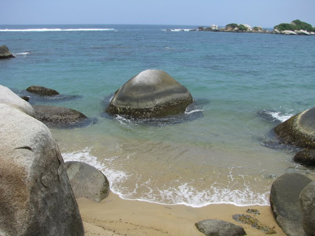
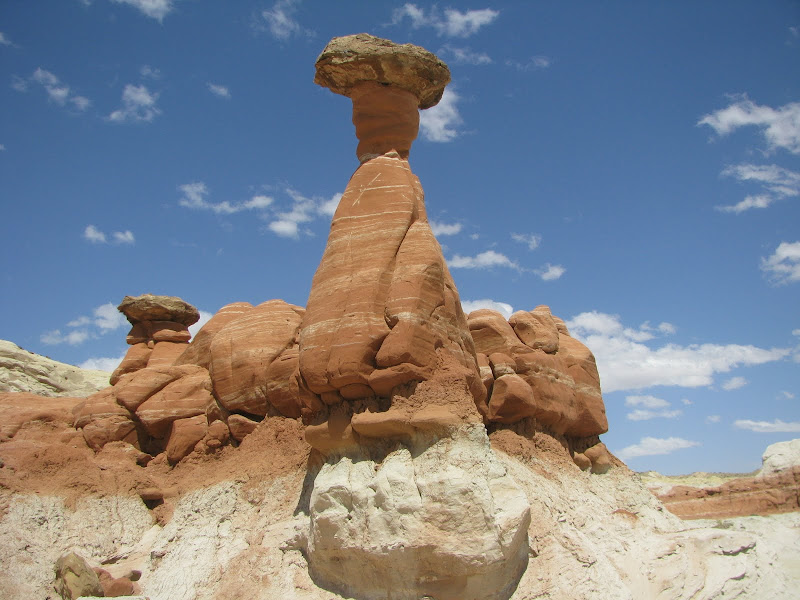
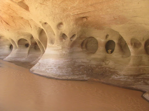
In Utah there are a lot of National States Parks, which are really incredible even look like dessert.

My personal recomedation, if you go to United States as a tourist is travel to this area, because you can go to all this National Parks, and visit the Grand Canyon because is very close and take advantage to visit Las Vegas.

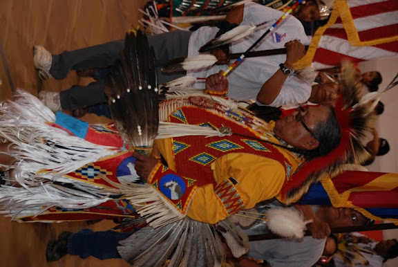
Thousands of years before the arrival of European explorers, the Anasazi and the Fremont tribes lived in what is now known as Utah. These Native American tribes are subgroups of the Ute-Aztec Native American ethnicity, and were sedentary. The Anasazi built their homes through excavations in mountains, and the Fremont built houses of straw before disappearing from the region around the 15th century. Another group of Native Americans, the Navajo, settled in the region around the 18th century. In the mid-18th century, other Uto-Aztecan tribes, including the Goshute, the Paiute, the Shoshone and the Ute people, also settled in the region. These five groups were present when the first European explorers arrived.

The southern Utah region was explored by the Spanish in 1540, led by Francisco VĆ”squez de Coronado, while looking for the legendary CĆ­bola. A group led by two Catholic priests—sometimes called the Dominguez-Escalante Expedition—left Santa Fe in 1776, hoping to find a route to the coast of California. The expedition traveled as far north as Utah Lake and encountered the native residents. The Spanish made further explorations in the region, but were not interested in colonizing the area because of its desert nature. In 1821, the year Mexico achieved its independence from Spain, the region of Utah became part of Mexico, as part of Alta California.

Trappers and fur traders explored some areas of Utah in the early 19th century. The city of Provo, Utah was named for one of those men, Ɖtienne Provost, who visited the area in 1825. The city of Ogden, Utah was named after Peter Skene Ogden, a Canadian explorer who traded furs in the Weber Valley. In late 1824, Jim Bridger became the first white person to sight the Great Salt Lake. Due to the high salinity of its waters, Bridger thought he had found the Pacific Ocean; he subsequently found that this body of water was nothing but a giant salt lake. After the discovery of the lake, hundreds of traders and trappers established trading posts in the region. In the 1830s, thousands of people traveling from the East toward the U.S. West began to make stops in the region of the Great Salt Lake.
Following the death of Joseph Smith, in Carthage, Illinois, in 1844, the more than 11,000 Latter Day Saints remaining in Nauvoo, Illinois struggled in conflict with neighbors until Brigham Young, the president of The Church of Jesus Christ of Latter-day Saints, emerged as the leader of the largest portion. (See Succession crisis.)

Brigham Young and the first band of Mormon pioneers came to the Salt Lake Valley on July 24, 1847. Over the next 22 years, more than 70,000 pioneers crossed the plains and settled in Utah.

For the first few years Brigham Young and the thousands of early settlers of Salt Lake City struggled to survive. The barren desert land was deemed by the Mormons as desirable as a place they could practice their religion without interference.

Utah was the source of many pioneer settlements located elsewhere in the West. Salt Lake City was the hub of a "far-flung commonwealth" of Mormon settlements. Fed by a continuing supply of church converts coming from the East and around the world, Church leaders often assigned groups of church members to establish settlements throughout the West. Beginning with settlements along Utah's Wasatch front (Salt Lake City, Bountiful and Weber Valley, and Provo and Utah Valley), irrigation enabled the establishment of fairly large pioneer populations in an area that Jim Bridger had advised Young would be inhospitable for the cultivation of crops because of frost. Throughout the remainder of the 19th century, Mormon pioneers called by Brigham Young would leave Salt Lake City and establish hundreds of other settlements in Utah, Idaho, Nevada, Arizona, Wyoming, California, Canada, and Mexico – including in Las Vegas, Nevada; Franklin, Idaho (the first white settlement in Idaho); San Bernardino, California; Star Valley, Wyoming; and Carson Valley, Nevada.

Prominent settlements in Utah included St. George, Logan, and Manti (where settlers raised the first three temples in Utah, each built many years before the larger and better known temple built in Salt Lake City was completed in 1893), as well as Parowan, Cedar City, Bluff, Moab, Vernal, Fillmore (which served as the territorial capital between 1850 and 1856), Nephi, Levan, Spanish Fork, Springville, Provo Bench (now Orem), Pleasant Grove, American Fork, Lehi, Sandy, Murray, Jordan, Centerville, Farmington, Huntsville, Kaysville, Grantsville, Tooele, Roy, Brigham City, and many other smaller towns and settlements. Young had an expansionist's view of the territory that he and the Mormon pioneers were settling, calling it Deseret – which according to the Book of Mormon was supposed to have translated into "honeybee" – hence the beehive which can still be found on the Utah flag, and the state's motto, "Industry."

Utah was Mexican territory when the first pioneers arrived in 1847. Early in the Mexican-American War in late 1846, the United States had captured New Mexico and California, and the whole Southwest became U.S. territory upon the signing of the Treaty of Guadalupe Hidalgo, February 2, 1848. The treaty was ratified by the United States Senate on March 11. The Utah Territory was created with the Compromise of 1850, and Fillmore was designated the capital. It was given the name Utah after the Ute tribe of Native Americans. Salt Lake City replaced Fillmore as the territorial capital in 1856.

Disputes between the Mormon inhabitants and the U.S. government intensified due to The Church of Jesus Christ of Latter-day Saints' practice of plural marriage, or polygamy, among its members. The Mormons were pushing for the establishment of the State of Deseret. The U.S. government, which had been reluctant to admit a state the size of the proposed Deseret into the union, opposed the polygamous practices of the Mormons.
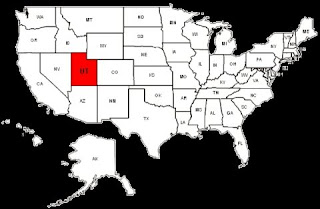

Utah political map:


Utah location map:


videos video photo photos pictures fotos United States Estados Unidos US USA travel trip holiday vacation vacaciones gratis free http://goplanettravel.blogspot.com goplanettravel gotravelphoto
December 2007

HOPE, ALASKA


Hope is a small poblation in the north central of Kenai peninsula.


Naika and me in the hope mountaions free tours rafting hope mountains


Naika and me in hope mountains fishing bears viewing Hope Mountains


Me in a car which took us hitchhiking in hope US USA Naika in RV´s parking in hope
videos video photo photos pictures fotos United States Estados Unidos US USA travel trip holiday vacation vacaciones gratis free http://goplanettravel.blogspot.com goplanettravel gotravelphoto
July 2008

PUFFIN, ALASKA


Puffin in Fjords National Park, Seward Alaska
videos video photo photos pictures fotos United States Estados Unidos US USA travel trip holiday vacation vacaciones gratis free http://goplanettravel.blogspot.com goplanettravel gotravelphoto
July 2008

SEA LIONS, ALASKA


Sea lion in Fjords National Park, Sewards, Alaska free Sea lions in Fjords National Park


Sea lions in Fjords National Park, Sewards, Alaska free Sea lions in Fjords National Parkvideos video photo photos pictures fotos United States Estados Unidos US USA travel trip holiday vacation vacaciones gratis free http://goplanettravel.blogspot.com goplanettravel gotravelphoto
July 2008


------------------------------------------------------------------------------------------------------ MUCH MORE ------------------------------------------------------------------------------------------------------
Packing List

Subway Maps

Currency Exchange

View Guestbook Sign Guestbook Weather Transportation Accomodation Maps